 In practice, the hydrologist is mainly concerned in tools
for specialized hydrological analysis. These applications
were designed and implemented by hydrologists during the project in order
to model the various hydrological processes and help in the understanding
and the effective conclusion of results regarding the water resources condition
either in a specific area, or in larger scales. The tools were used during
the phase of hydrological processing of the NDBHMI time series. Their vast
exploitation during the set up of the project proved that this group of
tools can be very effective for the hydrologist and the modeler, in the
process of evaluating the water resources, either locally or in a large
scale.
Analysis of double mass plots / Homogeneity checks
The construction of the double mass plots is the most common way of inspecting the homogeneity in rainfall timeseries. The method is applied in annual samples of two or more timeseries, where the first timeseries is used for the inspection of homogeneity, while the rest are considered to be homogenous. According to the methodology, a graph is plotted of the points with coordinates the cumulative rainfall of the dependent station on the X axis and the cumulative rainfall of the mean value of rainfall for the independent timeseries on the Y axis. A "break" in the line formed by these points indicates possible unevenness of the samples. In order for the method to be implemented correctly, many conditions should apply, such as the statistic independency of the timeseries along with an acceptable correlation of the timeseries.
Filling in / expansion of timeseries - correlation analysis
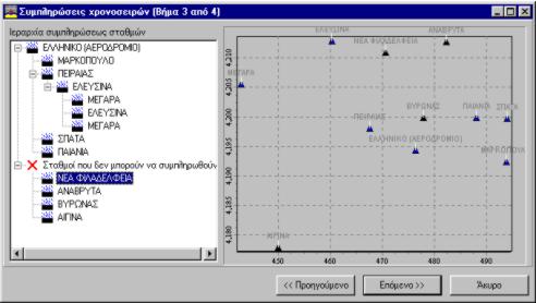 The method consists of a group of processes aiming at
the inspection of the statistical correlation of timeseries
and following the filling in of possible missing values using other complete
timeseries. This way the maximization of the available values of the timeseries
is achieved. In the context of NDBHMI, a specialized algorithm was developed
for the automatic correlation analysis of timeseries,
followed by the semi-automatic filling in of the timeseries gaps, based
both on geographical criteria such as the distance and elevation difference
between stations and statistical criteria such as the correlation coefficient,
the completeness of the timeseries data etc.
Idf curves estimation
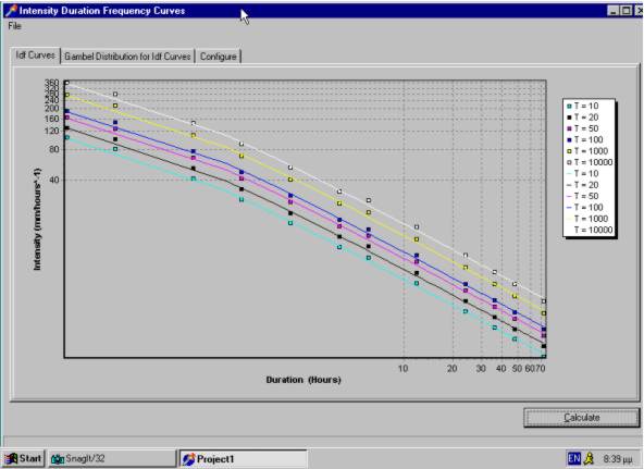 The idf curves are probably the most important tool for
hydrological planning as they are used in the design
and construction of sanitation networks, the inspection of the channel
efficiency, the construction of reservoirs etc. Idf curves are mathematical
equations which express the relation between the intensity, the duration
and the return period of the rainfall. The setting up of idf curves takes
place in three stages: extraction of maxima timeseries for several rainfall
durations, fitting in of a distribution in each maxima timeseries and finally
estimation of the idf curve parameters.
Stage - discharge curves estimation
 The hydrological variable that mostly concerns hydrologists
is river discharge. The study of discharges is useful
for the prediction of extreme events (i.e. the estimation of the maximum
discharge that will be routed through a spillway or a river bank) and is
also used for the calculation of water budgets. However, measuring discharge
is a complicated and expensive procedure. On the contrary, measuring the
stage of a river is a simple process, that is accomplished either with
the observer's visit on the site and reading the stage meter's readings
or with the use of stage gauges, which most of the times contain tapes
that last up to a week of stage recording in an hourly time step. Thus,
hydrometric measurements (simultaneous readings of stage and discharge)
take place occasionally, while recordings of stage occur on a regular time
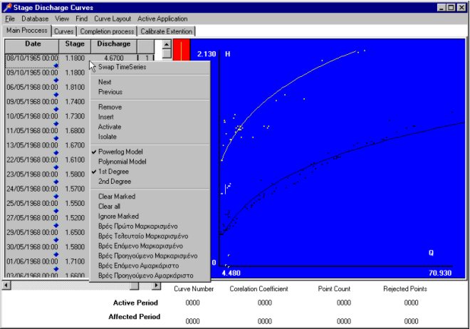
step (daily or hourly). The stage - discharge curves are mathematical equations
which are estimated using the pairs of stage - discharge measurements.
These equations are later used for the estimation of the timeseries of
discharge from the timeseries of stage. Specialized software was developed
in the context of NDBHMI, which models each step of the procedure for estimating
the stage - discharge curve, in every given position.
Discharge - sediment yield curves estimation
The flowing river water carries sediments which mainly originate from erosion of the river bed and banks. This phenomenon is called sediment transport and its study is important, since finally, the sediments are silted and after long year periods substantial quantities of sediments can be accumulated i.e. behind a dam, thus reducing its effective volume. The quantity that is mainly used for the study of sediment transport is sediment yield, which is the weight of sediments that come through the cross section of the river for a certain duration of time. The estimation of sediment yield timeseries is done in a similar way to the estimation of discharge timeseries. During the discharge measurements, simultaneous measurements of sediment yield also take place. Discharge - water yield curves are estimated from the sediment yield measurements. The timeseries of sediment yield is calculated using interpolation on these curves. In the context of NDBHMI a specialized software was developed, that models every step of the procedure for estimating the discharge - sediment yield curves for each position.
Statistical distribution fitting / Statistical analysis of time series
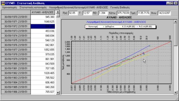 Statistical distributions are the main tool of hydrological
analysis, concerning the study of the dispersion of water
resources in nature. Most often specific statistical distributions are
used for specific applications, in order to effectively model samples of
measurements and to express the uncertainty which is intrinsic to those.
The distribution parameters are calculated using several methods, the most
common of which are the method of moments and the maximum likehood estimator
method, and these were used in the context of NDBHMI. Apart from fitting
each distribution in the measurement samples, the evaluation of goodness
of fit is also necessary, which is usually accomplished with the X2 test.
The application that was developed for the statistical analysis of timeseries models the following distributions and can apply the X2 test to any of them:
- Normal distribution
- LogNormal distribution
- Gumbel ελαχίστων
- Gumbel μεγίστων
- Weibull
- Gamma
- Exponential
- Pearson III
- Log-Pearson III
Hydrogeological parameters estimation
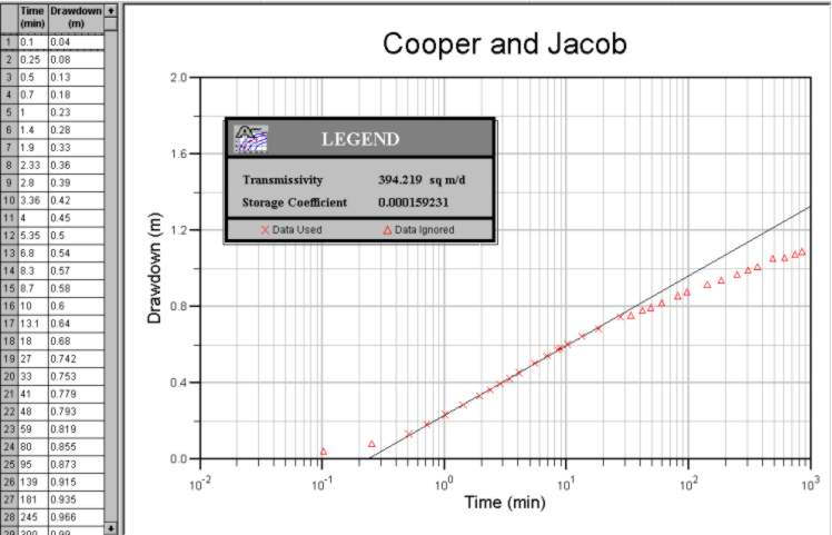 The main parameters of aquifers regarding their hydraulic
conduct are transmissivity and storativity. The estimation
of these parameters in the neighborhood of wells is done through pumping
tests. Subsequently maps can be drawn containing the distribution of these
parameters in the aquifers, by using appropriate methods of integrating
point measurements. Depending on the nature of the test and the data collected
it is possible to estimate other parameters such as the leakage factor
λ, information concerning the boundary conditions etc. In the context of
NDBHMI three different methods were examined (Theis, Cooper - Jacob and
Chow) for the estimation of the hydrogeological parameters. Finally the
Theis method was selected for the recovery and the Cooper - Jacob method
for the pumping.
Hydrological model application / Water balance estimation
The knowledge of the state, size, efficiency and the
spatial and temporal availability of water resources concentrates an enormous
scientific interest. Moreover, the interest is as
expected focused on the structural hydraulic works for the exploitation
of water resources and in particular on their optimal and less expensive
planning, and also on their best and reliable operation.
The estimation of the future hydrological processes in an area, requires the
knowledge of the generating mechanism of the water resource under study. In this
case the investigation focuses mainly on river discharges (with their maxima
and minima) and in the precipitations over watersheds. The models that simulate
the generating mechanism of water resources are then used for the setting up
of hydrological scenarios, in the sites of exploitation of the area under study,
that is for the estimation of the reallocation - changes of water resources in
the area. In the context of NDBHMI various hydrological models were developed
and applied in watersheds all over the country where available data existed.
